
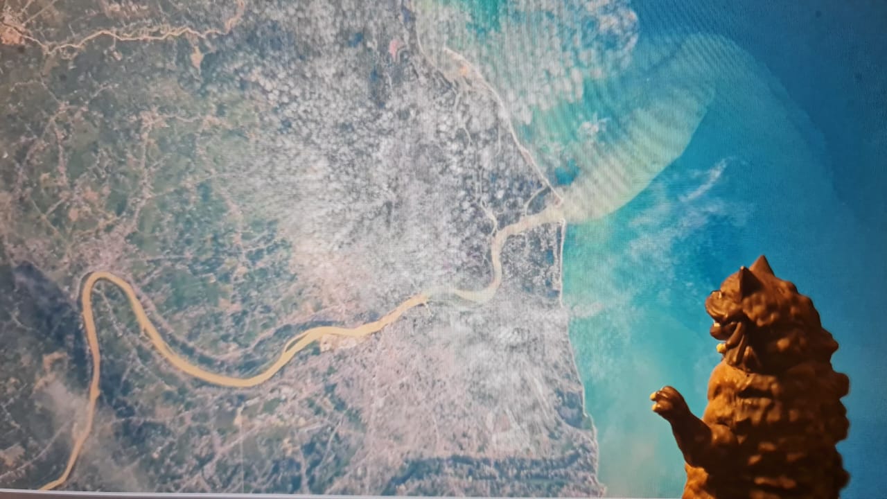
On 2 October 2025, the International Space Station (ISS) released a striking orbital image showing the Kelantan River as it flows across its floodplain toward the coast and empties into the South China Sea. In the photograph, the river appears dense and muddy, i.e. presumably its water was loaded with sediment, a visual many interpret as evidence of heavy sediment flow or “sediment pollution.”
That situation has appeared in major river in Kelantan which has been identified as unusual high sediment levels, often an indication of deeper geotechnical processes at work. Such turbidity often reflects accelerated upstream erosion, where soil and riverbank material loosened by rainfall, land-use change or deforestation enters the channel. This added sediment reshapes the riverbed, shallows the channel, affects flood behaviour and degrades water quality by blocking light, stressing aquatic life and smothering habitats.
What looks like a simple colour change is actually a quieter form of pollution: Erosion, a natural process amplified by human activity. Though less dramatic than chemical spills, it can impair river clarity, destabilize banks and threaten ecosystems and infrastructure. Tackling it demands an understanding of the soil mechanics and hydraulic forces that govern river stability and long-term resilience.
Riverbank erosion: More than just soil washing away
When most people imagine erosion, they picture dirt gradually drifting into a stream after heavy rain. However, riverbank erosion is much more complex. At its core, it involves the mechanical breakdown and movement of soil due to hydraulic forces, gravity and soil structure.
As water flows, especially during floods, it exerts shear stress on the banks. If this stress exceeds the soil’s shear strength, which is essentially a geotechnical property depending on cohesion, friction and moisture, the bank begins to fail. Once weakened, riverbanks collapse in blocks or slumps, adding large volumes of sediment into the water.
This sediment, although natural in small amounts, becomes a pollutant when the rate of erosion accelerates due to human activity such as deforestation, agriculture, construction and river engineering. The result is increased turbidity, or cloudiness, which directly affects water quality and river health.
Sediment: The hidden pollutant at work
Sediment might not seem like a pollutant; after all, rivers have carried sand and silt for millions of years. However, geotechnical and environmental sciences show that excess sediment can be as harmful as many chemical contaminants.
From the geotechnical perspective, fine-grained soils such as silts and clays can remain suspended in river water for long periods, keeping the flow turbid long after the initial erosion event. Although coarser particles settle more quickly, they too create significant challenges by altering riverbed geometry, increasing flood risk and reshaping natural flow patterns. Sediment is far more than “dirt in the water”, it is a dynamic, systemwide pollutant that influences river behaviour, stability and ecology from bank to bed.
Furthermore, when erosion accelerates, sediment concentrations rise far above natural levels, triggering a cascade of ecological impacts. The increased turbidity reduces sunlight penetration, which limits photosynthesis for aquatic plants and disrupts the base of the food chain. Suspended particles can clog the gills of fish, placing stress on sensitive species and sometimes causing mortality. As sediments settle, they smother fish spawning beds, particularly those requiring clean gravel, thereby affecting reproduction. At the same time, soil particles often carry attached pollutants such as fertilizers, heavy metals and pesticides, allowing these contaminants to spread throughout the river system and compound the overall degradation of water quality.
Riverbed transformation: How erosion resculpts the channel
As sediment loads increase, riverbeds undergo physical changes that intensify long-term degradation. This is where geotechnical engineering intersects strongly with hydraulic science.
When substantial amounts of sediment settle on the riverbed, they trigger significant physical changes within the river system. The accumulation can raise the bed level, reduce channel depth and increase the frequency and extent of flooding. Altered sediment distribution also affects flow velocity, which can sometimes accelerate erosion further downstream. As the riverbed composition shifts, habitats change as well, with clean gravel beds being replaced by fine silt that disrupts the living conditions of many aquatic species as discussed above. In addition, excessive sedimentation can cause the river channel to shift, prompting the river to meander more aggressively or even carve entirely new paths across the landscape.
It follows that engineers often monitor bedload transport, that is the movement of larger particles along the riverbed, because increases in upstream erosion elevate this bedload, making the river more unstable and unpredictable. Such instability can endanger bridges, embankments, pipelines and other nearby infrastructure. Erosion does far more than pollute rivers; it actively reshapes them.
Accelerated erosion: Causes, consequences and sustainable controls
Human activities accelerate what is otherwise a natural process, pushing sediment levels in rivers far beyond what they can naturally sustain. Deforestation and land clearing remove vegetation that anchors soil, agricultural practices expose bare earth to erosion, while construction, mining, and riverbank modifications disturb soil layers while channeling stormwater directly into waterways. Poorly designed river engineering, such as rigid embankments or misplaced levees, can further disrupt flow patterns and intensify downstream erosion.
Recognizing these drivers underscores that erosion is often a result of land-use decisions rather than “nature taking its course.” Fortunately, geotechnical and environmental strategies exist to counter these effects: Planting deep-rooted vegetation to increase soil cohesion, regrading unstable banks to gentler slopes, reinforcing banks with geotextiles, constructing sediment traps, restoring wetlands and floodplains, and enforcing careful land-use planning near vulnerable waterways. Together, these methods work with natural processes to strengthen soils, reduce hydraulic stresses and build long-term river resilience.
Protecting rivers against erosion
Erosion may be silent, but its effects are loud: Murky water, unstable banks, degraded ecosystems and shifting riverbeds. By understanding the geotechnical science behind erosion, the public can better appreciate both the fragility and the resilience of river environments. Protecting rivers requires thoughtful land management, responsible development, and engineering practices that respect the balance of soil, water and flow.

Prof. Ir. Dr. Chan Chee Ming
Faculty of Engineering Technology
Principal Researcher
Research Centre for Soft Soils (RECESS)
Universiti Tun Hussein Onn Malaysia